CBA Samoa: Adaptation to Flooding and Sea Level Rise - Fagamalo
Project Overview


Fagamalo village was once the government centre for the north of Savaii, with the district hospital, district secondary school, government offices, and businesses all located here. But cyclones Ofa and Val in the early 1990's totally destroyed all of the government infrastructure and businesses, and decimated most of the village residences along the shore. Approximately 50 meters of the coastline have been eroded by cyclones and subsequent strong wave surges. While several families have relocated inland, the majority of the villagers still reside on the coast due to the convenient access to the ecosystem they rely on for their livelihoods.
This Community-Based Adaptation project reduces the impacts of cyclones and flooding on households, the wetland, and coastal ecosystems around Fagamalo by taking out the existing rock jetty that has contributed to rapid coastal erosion. The project also supports the coral regrowth in the inshore reef. To diminish flooding risks, the existing access road will be upgraded. The upgraded, unsealed access roads will also provide easy access to higher grounds during natural disasters such as tsunamis, cyclones, and strong wave surges. On normal days when cyclones are not a threat, the upgraded roads will reduce land-based pollution from affecting the wetlands.
* This project is part of UNDP's "Community-Based Adaptation" portfolio. *


Project Details
Samoa is an archipelago in the South Pacific, consisting of two large mountainous islands, Upolu and Savai’I, and seven other small islands. The majority of Samoan people live within one kilometer of the coast leaving them highly vulnerable to climate change hazards such flooding and sea level rise. This holds true for Fagamalo village, which is located in the northern most point of the island of Savai’i. This site is home to threatened ecosystems including coral reefs, mangroves and mixed herbaceous coastal marsh. The marine biodiversity includes over 40 coral species and 60 fish and marine invertebrates.
Fagamalo’s 700 residents depend largely on plantations and fishing for their livelihoods. The village fronts the sea with the outer reef break approximately 200 meters from the beach. Due to its proximity to the coast, Fagamalo and its wetlands are vulnerable to climate variability and extreme weather patterns that can result in coastal erosion and flooding. Cyclones, like those of the 1990’s, can cause damage to critical ecosystems, agricultural crops, livestock and homes leaving areas unsafe for permanent habitation.
Climate change projections for Samoa predict an increase in average temperatures, a decrease in total precipitation, more high intensity rainfall events, a rise in sea level, and a perceived increase in the severity of tropical cyclones. During the rainy season, coastal erosion and flooding events have adversely impacted the project area. Beginning in the early 1990’s, climate change started being felt in this part of the country. The village is now facing rapid coastal erosion driven by increasing storm intensity and declining resilience of buffering coral ecosystems and littoral plants. As a result, homes that used to be located farther from the sea are now closer to the coast. In addition to coastal erosion, erratic and heavy rainfall results in the flooding of over 70% of the village area, damaging homes, crops, livestock and roads. Faced with heightened climate change risks, residents who rely upon natural ecosystems will find it increasingly difficult to sustain their livelihoods.
This Community-Based Adaptation project seeks to reduce the vulnerability of Fagamalo village and its surrounding ecosystems to adverse impacts of climate change in general, and to flooding and coastal erosion in particular. The project emerged from the Samoan Government’s Coastal Infrastructure Management (CIM) planning initiative. It was prepared through a participatory process involving all segments of the community.
The project is designed to increase the adaptive capacity of the community to climate change through a variety of activities. The current walking path will be upgraded to an unsealed access road in order to expedite upland evacuation when cyclones, high waves and flooding affect the village. This will also act as a natural barrier to wetland flooding while reducing pollution by stopping the dumping of rubbish behind homes. The existing rock jetty will be removed to allow for the natural flow of sand and inshore currents, thus reducing coastal erosion and associated effects on the coral reef.
The project also contains an awareness-raising programme to help community members better understand climate change and its associated risks and impacts. Altogether, these activities provide the village with human and infrastructure capacities necessary to increase the resilience of the ecosystems and households to climate change variability.
Key Results and Outputs
Outcome 1.0: Increased coastal ecosystems resilience in face of climate change impacts
Upgrade access road (Output 1.1), remove rock jetty (Output 1.2), and replant coastal ecosystems (Output 1.3).
Outcome 2.0: Developed community capacity to manage resilient local ecosystems
Implement awareness-raising programme (Output 2.1) and wetland pollution prevention programme (Output 2.2).
Reports and Publications
Brochures, Posters, Communications Products
PIFs
Multimedia
TOFIGA O PILI AAU - Samoa CBA Project (Pt. 2)
This is a shortened version of an original 25-minute video created through a participatory process at the sites of UNDP's Community-Based Adaptation projects in Samoa. It features the initiatives of vulnerable communities as they act to mitigate the impacts of climate chaneg on their environment, livelihoods and infrastructure.
TOFIGA O PILI AAU - Samoa CBA Project (Pt. 1)
This is a shortened version of an original 25-minute video created through a participatory process at the sites of UNDP's Community-Based Adaptation projects in Samoa. It features the initiatives of vulnerable communities as they act to mitigate the impacts of climate chaneg on their environment, livelihoods and infrastructure.
Monitoring and Evaluation
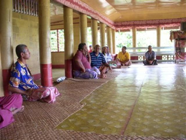
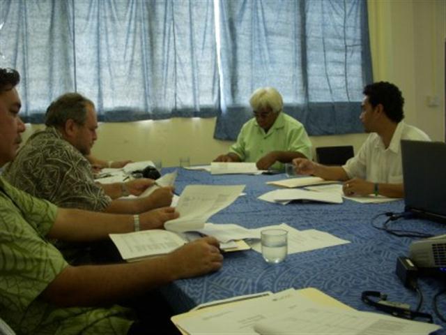
The assessment on the impacts of climate change on the communities started in the development of the CIM Plans in 2007. In these consultations, all sectors of the community were provided with maps of the area, whereby affected areas from climate changed were identified and visited. These consultations identified cyclones, flooding, and coastal erosion as the main climate risks and were seen as extremely damaging noting that the majority of the old village was destroyed. In between the cyclones, the village identified flooding as the most regular climate risk issue where the inland road to the new homes mostly get blocked, while the stream overflows onto the road, the church and remaining homes along the coast.
The VRA analysis was process undertaken with the village over the last two years, attended by all sectors of the village but in several instances, by mixed group of participants. In the last workshop held on May 14th 2009, the village reiterated that rather than again going through the process, they supported all the issues raised in previous consultations.
In identifying possible options to reduce the climate risks, the village using information already gathered from the CIM Plan, and the VRA process, identified flooding, cyclones and coastal erosion as the main climate risks. The impacts of flooding, cyclones and strong wave surges were identified as safety of people, agricultural crops, livestock, and homes. Environmentally, it was also recognized that the climate risks also impact on the critical ecosystems such as coral reefs, and the wetlands that provide ptertinent ecological services that support human.
To reduce the vulnerability to cyclones, flooding and coastal erosion, the main activities agreed upon were the upgrading of the access road so families could easily access the uplands when cyclones, high waves and flooding affect village. This actions was also seen as a way of protecting the wetlands and biodiversity from continued pollution from household activities, waste disposal and feral pigs.
To reduce the vulnerability on the increasing sea level rise, the village agreed to take out the existing rock jetty to allow for the natural flow of sand and inshore currents, thus reducing coastal erosion.
Other issues identified in the CIM Plan as impacts of climate change included the lack of water supply within the village and district, especially for families that have moved inland from the coast. The new project for the district for upgrading its water supply network has been approved for funding by the European Union. The maintenance of existing public roads along the village has now been taken up by the MWTI.