Climate-resilient development & enhanced adaptive capacity for disaster risk in Angola’s Cuvelai River Basin
Project Overview
The Cuvelai Basin has experienced regular flooding for centuries; however over the past three hydrological years (2008-2011) the Basin has had extensive floodings with various negative repercussions, including loss of life and property. According to the Angola Civil Protection Commission, at least 234 persons were killed, 204,000 displaced and 254,000 directly affected by flooding between January and April 2011 throughout Angola. The Cuvelai Basin region was especially impacted. Heavy rainfall made access to communities difficult, with some areas only reachable by air. At the same time, many years in the Basin are extremely dry. Almost all rain falls in the summer months and the further south in the Basin the more unpredictable the rainfall; this is typically the area where the most extreme droughts occur. The driest among these in recorded history have led to catastrophic famines, the most disastrous of which resulted in the deaths of up to 40% of the people in the Basin. Moreover the timing of summer rainfall within one summer may be so erratic that crops fail, even if the total aggregate amount of rainfall received is high.
The activities in this project are solely focused on the Angolan side of the Basin. Namibia started its basic monitoring systems (and disaster early warning systems) in the 1940s and is one of the countries in SADC that has a wide range of monitoring data available. The Namibian Hydrology Division in the Department of Water Affairs and Forestry (DWAF) continuously monitors the stream flow on the major rivers in Namibia, including those within the Cunene River Basin; it has river water level stations in operation at Ruacana and Epupa on the Cunene River; and operates river gauging stations (Ombuku, Minimahoro) on the ephemeral tributaries of the Lower Cunene River. Whereas almost every homestead in the Namibian side of the Basin can be reached along roads or tracks that are clearly visible on Google Earth images, the same images show that most homesteads on the Angolan Cuvelai have never or seldom been visited by vehicles. Moreover the great majority of livelihoods in the Angolan side are subsistence-oriented and dependent on rain‐fed agriculture whereas the Namibian inhabitants of the basin are much less vulnerable to climate-induced shocks.


Project Details
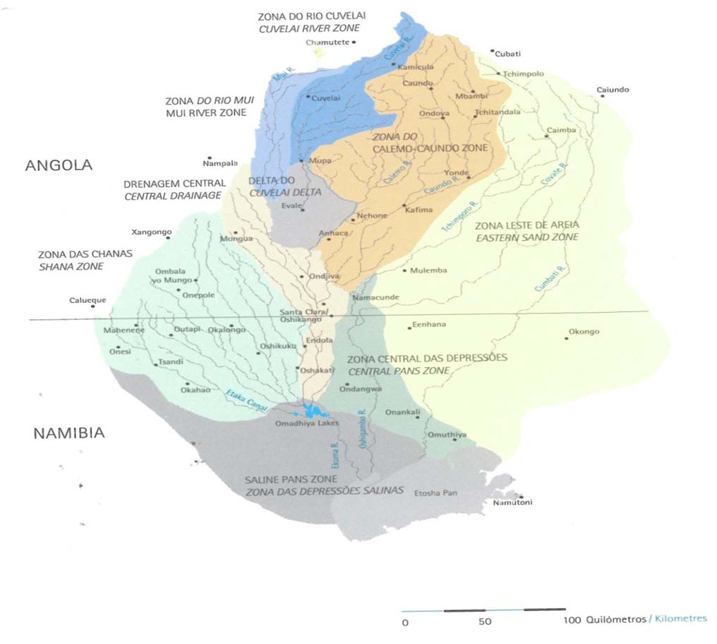
As noted in the opening of a ground-breaking study published in 2011, the “Cuvelai is different!” It is not a delta nor a river nor an alluvial fan. The Cuvelai Basin is perhaps unique in the world as a drainage system that consists of hundreds of channels that join and separate thousands of times. It has a geographical area of 159,620 km2 split between Angola and Namibia, extends over 450 kilometers from north to south and covers more than half of the Province of Cunene in Angola. Slivers of the Cuvelai Basin also lie within the Angolan provinces of Cuando Cubango and Huila. Part of Cuvelai’s water comes from the headwaters on the southern slopes of the Angolan highlands but most channels begin as broad courses right along the Cunene River. The Cunene River is 1,050 km long and is one of the few perennial rivers in this region with a mean annual discharge of 5.5 km³ at its mouth. Local rivers provide water to these channels (called iishanas) that mesh, network and divide on their way downstream to the famous Etosha Pan. For much of the year, most channels hold no water and fill only after summer rains. Rainfall in the northern-most catchment area averages about 900 mm per year, just over double the historical average of 400 mm in the south. Compared to surrounding areas the Cuvelai Basin is home to a very large number of people, largely because of the presence of shallow groundwater and relatively fertile soil in many areas. Among the many livelihood activities practiced by local people are rain-fed agriculture and livestock-raising, principally cattle. The borderland of the Basin is clearly visible from space due to the fact that there have been considerably higher rates of deforestation on the Namibia side compared to the Angola side.
This project specifically focuses on support for NAPA priorities 7 (Create an early warning system for flooding and storms) and 13 (Climate monitoring and data management system). These two NAPA priorities are intricately linked (and have therefore been bundled together for the purpose of this project) since establishment of a comprehensive famine and flood early warning systems (FFEWS) – including downscaled seasonal forecast delivery systems – is one key component of a more broad-based climate monitoring and data management system, which also includes climate information dissemination and capacity-building. As the NAPA notes, there is “insufficient climate monitoring infrastructure in Angola and as a result, early warning is nearly impossible in the country.” Agricultural planning and extension is also made difficult due to the lack of appropriate seasonal forecasts and climate monitoring information; even if systems are established the data must be shared with key stakeholders at the local level to develop appropriate site-specific responses, such as distribution of flood-resistant seed varieties.
In addition to responding to these NAPA priorities as classified on a sectoral level, the project has been specifically designed to address the specific needs of a particularly vulnerable region of the country: the Angolan portion of the Cuvelai River Basin and more specifically the Province of Cunene (see Section B). In an effort to better understand the different dimensions of vulnerability across the whole country, as part of the NAPA formulation process it was decided to divide Angola into various geographic areas in which each one represented a type of vulnerability. In each province, consultations took place at 4 different levels: with local authorities, non-governmental organisations, private sector entities as well as the population of specific locations providing evidence as to the types of vulnerability in a certain area and providing input into a list of context-specific adaptation priorities.
The province of Cunene was chosen as the NAPA priority province for “integrated vulnerabilities” due to a rare confluence of factors that classify it as the most vulnerable province in the country as regards significant climate-induced risks, particularly as it applies to what was identified as the highest ranked topical threat in the NAPA: flooding and water-induced soil erosion. Thus the populations who will most directly benefit from this project are those that are most vulnerable to floods and other disasters due to the risks factors identified in the NAPA.
Finally in line with LDCF guidelines the project is based on a learning-by-doing approach. Angola has recently emerged from what was one of Africa’s most protracted conflicts. The civil war between 1975 and 2002 resulted in the destruction of infrastructure and the breakdown of institutions of all kinds. The ability of the Angolan Government to maintain an administrative presence and collect and monitor data of all kinds during this period was also negatively impacted by the war. The primary geographic focus of this project – the Cuvelai River Basin – was one of the regions most affected by the war and remains poorly understood by both development practitioners and climate experts, both as regards its basic geography (climate, soils and hydrology) and socioeconomic characteristics. In many Angolan provinces there has been almost no donor presence until recently. At the same time decentralization, or the delegation of administrative and fiscal responsibilities to sub-national units of government, is slowly taking place in Angola albeit at a slow and uneven pace; much information gathered at national levels still does not reach local authorities. This particular project involves several layers of government – from national entities to provincial and municipal level authorities – and builds on a variety of recently proposed initiatives that seek to address the complex climate-related challenges facing this critically important trans-boundary wetland. As such this project will by default need to assume a rigorous adaptive management approach and adopt a learning and information-sharing orientation from the onset, with the potential to indirectly benefit a much larger population than just its intended beneficiaries and hopefully inform the development of similar multi-stakeholder efforts in other provinces of the country. The GoA, in partnership with USAID efforts, will seek to communicate all relevant findings, conclusions and recommendations to neighboring governments as well as SADC experts on climate‐related disasters.
Key Results and Outputs
Component 1: Transfer of appropriate technologies and related capacity building for climate and environmental monitoring infrastructure
• Establishment of a comprehensive famine and flood early warning systems (FFEWS), including downscaled seasonal forecast delivery systems, that take into account climate change induced drought and flood events in the Cuvelai Basin
• Procurement and installation or rehabilitation of at least 3 gauging stations and at least two hydrometric stations in the Basin
• Procurement and installation of satellite monitoring equipment
• Training of at least 5 officers in the Provincial government and Civil Protection to operate and maintain climate monitoring infrastructure
• Strengthen the Civil Protection’s capacity for assimilating forecasts and monitoring into existing development planning, and disaster management systems, including the provincial contingency plan.
• Communication channels and procedures for issuing warnings (through both governmental and non-governmental agencies) are enabled (e.g. radio, newspapers, mobile phones, television etc).
Component 2: Enhanced human and institutional capacity for increased sustainable rural livelihoods among those communities areas most prone to flooding in the region.
• Livelihoods assessment conducted of the spatial density and location of all smallholder farming communities in the Angolan side of the Basin that are vulnerable to climate impacts
• Establishment of online registry of vulnerability data and population density from assessment
• Identification of of locally appropriate, climate-resilient germplasm resources for the Basin from the National Plant Genetic Resources Centre (CNRF) database
• Establishment of at least three demonstration plots in the Basin for climate-resilient crop varieties
• Dissemination of climate-resilient seed packets (from CNRF database) for multiplication to smallholder farmer groups , leading to improved yields and food securty indicators
Component 3: Increased understanding of climate change adaptation and practices in climate-resilient development planning at the local community and government levels
• Updating of Province of Cunene Master Plan as regards best practices in climate-resilient development planning
• All Civil Protection officials in Province receive training on climate change impacts and adaptation measures
• Awareness raising campaigns about climate change impacts on watershed resources and on human activities undertaken at village level in 300 sites
• Case studies developed and disseminated that capture traditional knowledge about climate change management at local leve
• Development and annual dissemination of micro-seasonal maps of adaptability of different climate resilient crops to all Provincial rural extension agents
Reports and Publications
PIFs
PIF: Promoting Climate-Resilient Development - Cuvelai River Basin, Angola. 09 Oct 2012
Monitoring and Evaluation
The implementation of the project’s activities will reflect UNDP-GEF monitoring and evaluation standards and procedures, in line with the requirements of the LDCF. Details for monitoring and evaluation will be articulated during the project development phase.
More information to come...